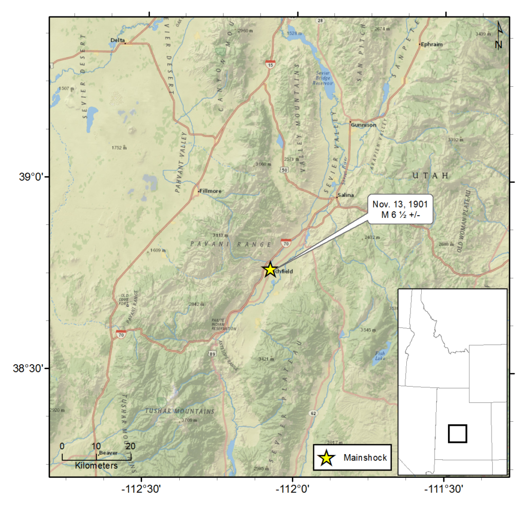
November 13, 1901 - Southern Utah - M 6½±
A magnitude 6½ ± earthquake occurred near Richfield, Utah, at 9:39 p.m. on Wednesday, November 13, 1901. The earthquake was reported felt within an area of 130,000 km2 (roughly 50,000 mi2).
There were reports that the earthquake was accompanied by a roaring sound. The earthquake caused suspended light fixtures to swing, and stopped clocks in many locations. There were a number of reports that the earthquake alarmed animals causing them to call out and behave erratically.
Utah towns reporting damage included: Richfield, Beaver, Joseph, and Elsinore. In these locations there were widespread instances of downed chimneys, cracked walls—particularly in stone and brick buildings, roofs damaged by falling chimneys, and broken windows. Dishes and other goods were shaken from cupboards or shelves and broken. People were greatly frightened with some fainting or rushing into the street.
No loss of life was reported as a result of this earthquake. However, there were reports of a number of near misses from falling walls and ceilings.
Near Marysvale, Utah, cracks in the ground were observed, measuring anywhere from one to 18 inches in width and from a few feet to three hundred feet in length. From some of the larger cracks, fine white sand and water was ejected.
About a mile east of Koosharem, Utah, the ground was greatly disturbed. Some places had sunk and in other places soft earth was thrown up. In one location, earth slid down covering a canal. There was also a report of large ground cracks up to three feet wide, filled with water.
Bullion and Cottonwood canyons, near Marysvale, Utah, were rendered almost impassable from large rocks that rolled down onto roads. Near Junction, Utah, large rocks rolled down from hills in East Fork canyon damaging the wagon road. In some places the water volume of creeks increased 30-50 percent.
There were reports of flashes of light along the ridges and crests of mountains in Piute and Sevier counties.
The earthquake was also reported felt in Salt Lake City, Utah, particularly by those in upper floors of buildings.
For additional information about this earthquake:
Earthquake Summary Newspaper Articles Photos Additional Resources
Intermountain Seismic Belt Historical Earthquake Project
- 1945 Flathead Lake, MT M5.5
- 1952 Bigfork, MT M5.5
- 1935 Helena, MT (series) M6¼
- 1928 Helena, MT M 5 ½ ±
- 1929 Lombard, MT M 5.6
- 1925 Clarkston Valley, MT M 6¾
- 1947 Virginia City, MT M 6¼
- 1959 Hebgen Lake, MT M 7.5
- 1975 Yellowstone National Park , WY M 6.1
- 1945 Central Idaho M 6.0
- 1944 Central Idaho M 6.1
- 1983 Borah Peak, ID (series) M 7.3
- 1905 Shoshone, ID M 5½ ±
- 1994 Draney Peak, ID M 5.9
- 1930 Grover, WY M 5.8
- 1975 Pocatello Valley, ID M 6.0
- 1962 Cache Valley, UT M 5.7
- 1884 Bear Lake, ID M 6.3
- 1909 Hansel Valley, UT M 6±
- 1934 Hansel Valley, UT (series) M6.6
- 1914 Ogden, UT M 5½ ±
- 1894 Ogden, UT M 5.0
- 1910 Salt Lake City, UT M 5½±
- 1949 Salt Lake City, UT M 5.0
- 1943 Magna, UT M 5.0
- 1962 Magna, UT M 5.2
- 1958 Wallsburg, UT M 5.0
- 1915 Provo, UT M 5.0
- 1900 Eureka, UT M 5½ ±
- 1876 Moroni, UT M 5.0
- 1961 Ephraim, UT M 5.0
- 1988 San Rafael Swell, UT M 5.3
- 1989 So. Wasatch Plateau, UT M 5.4
- 1901 Southern Utah M 6½±
- 1945 Glenwood, UT M 5.0
- 1910 Elsinore, UT M 5.0
- 1921 Elsinore, UT (series) M 6±
- 1967 Marysvale, UT M 5.2
- 1908 Milford, UT M 5.0
- 1959 Panguitch, UT M 5.0
- 1933 Parowan, UT M 5.0
- 1942 (Aug) Cedar City, UT M 5.0
- 1942 (Sept) Cedar City, UT M 5.0
- 1902 Pine Valley, UT (series) M 6
- 1992 St. George, UT M 5.8
- 1891 St. George, UT M 5.0
- 1887 Kanab, UT M 5.7
- 1959 Kanab, UT M 5.7

