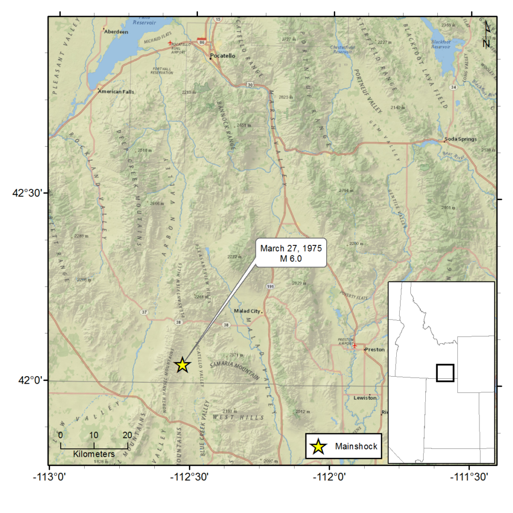
March 27, 1975 - Pocatello Valley, ID - M 6.0
A magnitude 6.0 earthquake occurred approximately 15 miles southwest of Malad City, Idaho, on Thursday, March 27, 1975 at 7:31 p.m.
Shaking from the earthquake was reported felt as far north as Idaho Falls, Idaho, as far south as Richfield, Utah, as far east as Rock Springs, Wyoming, and as far west as Wells, Nevada. However, the greatest amount of property damage occurred in Malad City, located about 40 miles from the epicenter.
The damage in Malad City was widespread—almost every home and building was affected. An April 11 newspaper report noted that 520 homes and 26 businesses were damaged by the earthquake shaking with seven homes completely destroyed.
Damage included: cracked and collapsed walls, cracked and fallen plaster, cracked foundations, buildings shifted from foundations, downed chimneys and damaged roofs, broken windows and at least one collapsed fireplace. Additionally, dishes and goods fell from shelves and were broken and pictures fell from walls. In some places in town, fallen bricks and mortar littered the streets. Phone service in some areas was temporarily interrupted.
No deaths were reported in connection with the earthquake. There was one reported injury consisting of minor cuts and bruises caused by a falling roof panel.
In the Pocatello Valley, seasonal-use buildings showed damage including: shifting off foundations, cracked walls and downed chimneys. Dishes and goods in cupboards were spilled onto floors. A silo in the area collapsed, spilling grain out onto the ground. Some irrigation wells in the area were also feared to be damaged.
Two large ground fractures north of the Utah-Idaho border were discovered. One fracture, a mile in length, and the other, 200 feet in length were later determined to be fault lines.
In some Utah communities, telephone circuits were overloaded with calls, causing temporary service outages. The earthquake caused a broken water main in Bothwell, Utah. A broken water line and damage to a school building in Salt Lake City were both attributed to the earthquake.
For additional information about this earthquake:
Earthquake Summary Newspaper Articles Photos
Personal Accounts Additional Resources
Intermountain Seismic Belt Historical Earthquake Project
- 1945 Flathead Lake, MT M5.5
- 1952 Bigfork, MT M5.5
- 1935 Helena, MT (series) M6¼
- 1928 Helena, MT M 5 ½ ±
- 1929 Lombard, MT M 5.6
- 1925 Clarkston Valley, MT M 6¾
- 1947 Virginia City, MT M 6¼
- 1959 Hebgen Lake, MT M 7.5
- 1975 Yellowstone National Park , WY M 6.1
- 1945 Central Idaho M 6.0
- 1944 Central Idaho M 6.1
- 1983 Borah Peak, ID (series) M 7.3
- 1905 Shoshone, ID M 5½ ±
- 1994 Draney Peak, ID M 5.9
- 1930 Grover, WY M 5.8
- 1975 Pocatello Valley, ID M 6.0
- 1962 Cache Valley, UT M 5.7
- 1884 Bear Lake, ID M 6.3
- 1909 Hansel Valley, UT M 6±
- 1934 Hansel Valley, UT (series) M6.6
- 1914 Ogden, UT M 5½ ±
- 1894 Ogden, UT M 5.0
- 1910 Salt Lake City, UT M 5½±
- 1949 Salt Lake City, UT M 5.0
- 1943 Magna, UT M 5.0
- 1962 Magna, UT M 5.2
- 1958 Wallsburg, UT M 5.0
- 1915 Provo, UT M 5.0
- 1900 Eureka, UT M 5½ ±
- 1876 Moroni, UT M 5.0
- 1961 Ephraim, UT M 5.0
- 1988 San Rafael Swell, UT M 5.3
- 1989 So. Wasatch Plateau, UT M 5.4
- 1901 Southern Utah M 6½±
- 1945 Glenwood, UT M 5.0
- 1910 Elsinore, UT M 5.0
- 1921 Elsinore, UT (series) M 6±
- 1967 Marysvale, UT M 5.2
- 1908 Milford, UT M 5.0
- 1959 Panguitch, UT M 5.0
- 1933 Parowan, UT M 5.0
- 1942 (Aug) Cedar City, UT M 5.0
- 1942 (Sept) Cedar City, UT M 5.0
- 1902 Pine Valley, UT (series) M 6
- 1992 St. George, UT M 5.8
- 1891 St. George, UT M 5.0
- 1887 Kanab, UT M 5.7
- 1959 Kanab, UT M 5.7

