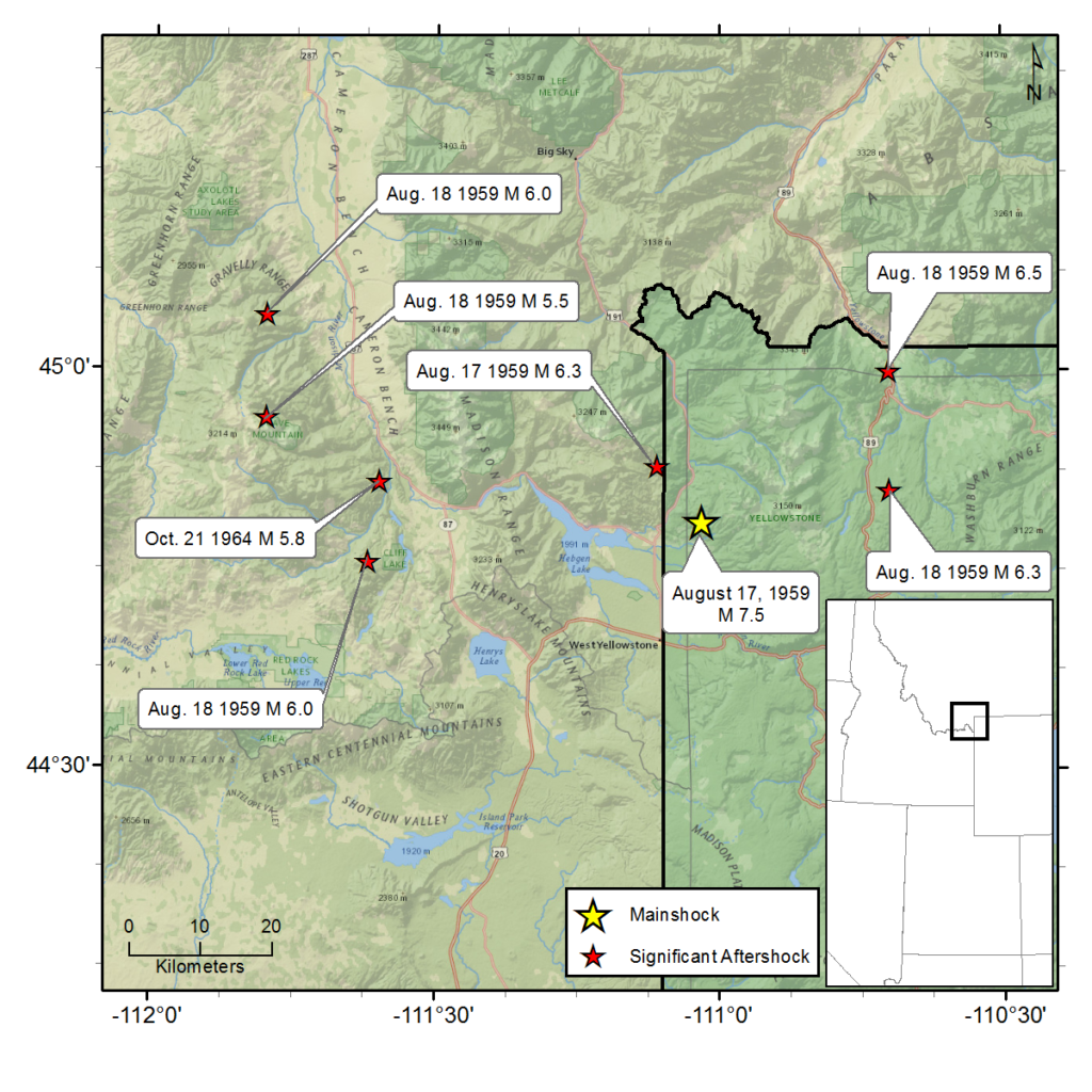
August 17, 1959 - Hebgen Lake, MT - M 7.5
The Hebgen Lake earthquake—the largest and deadliest earthquake recorded in Montana and the Intermountain West—occurred at 11:37 p.m. (local time) on Monday, August 17, 1959. The epicenter of the magnitude 7.5 earthquake was approximately 15 miles north of West Yellowstone, Montana (later revised by the U.S. Geological Survey to magnitude 7.3 and located 6.5 miles northwest of West Yellowstone). The earthquake was reported felt as far north as Banff, Canada; as far south as Provo, Utah; as far east as Dickinson, North Dakota; and as far west as Seattle, Washington (Stover and Coffman, 1993). Seven significant aftershocks ranging in magnitude from 5½ to 6½ occurred in the three months following the mainshock.
The greatest number of reported injuries and deaths occurred in the Madison River Canyon where the earthquake triggered an 85-million-ton landslide on a mountain five miles west of Hebgen Lake. The landslide roared down over a popular recreation area where an estimated 200 people were camping. The earthquake also caused a northward tilt of the Hebgen Lake bed. This triggered a reported 20-foot wall of water that overtopped Hebgen Dam followed by several 3-4 foot surges. Eyewitnesses reported seeing camping trailers swept down into the Madison River, cars and their occupants buried in dirt and rock, and trees flying through the air. There were reports of screams and cries for help. Twenty-eight individuals died from their injuries or were presumed buried in the slide.
The landslide dammed the Madison River, creating what became known as “Quake Lake.” Montana Highway 287, the primary route through the Madison River Canyon, was rendered impassable due to slide debris, fault scarps (as high as 18 feet) and sections of the highway that fell into Hebgen Lake.
Emergency responders parachuted into the area to establish communication and to provide first-aid. The injured were evacuated by helicopter to an aid station in West Yellowstone and then on to nearby hospitals by airplane. Deceased were airlifted to a morgue in the town of Ennis, Montana. Remaining survivors were able to evacuate later on roads that had been cleared or newly constructed.
According to one report, the ground shaking produced sixteen cracks in the Hebgen Dam. In spite of the damage it was determined the dam would hold. However, precautions were taken to evacuate the town of Ennis 45 miles away and to warn residents in the Madison Valley. The Army Corps of Engineers moved quickly to construct a spillway at Quake Lake before the rising waters topped the landslide dam. Additional earthquake tremors slowed work on roads and dams as well as search and rescue efforts.
When it was determined that no other victims would be recovered from the landslide, a brief memorial service was held near the mouth of the Madison River Canyon. Officiators from several denominations led the group of approximately 50 attendees in prayer. They also consecrated the slide as the final resting place for those who had perished.
The West entrance to Yellowstone National Park was closed with no travel possible along the park’s west side due to landslides, rockfalls and bridge damage. One individual in West Yellowstone at the time of the earthquake reported hearing an awful roar, felt his cabin shaking and lost electrical power. No buildings collapsed but many were severely cracked or damaged. Thousands of frightened tourists left the park, while curious onlookers arrived to survey the damage.
In Billings, Montana, the earthquake awakened hundreds of residents who reported swinging light fixtures, rattling dishes, rolling beds, swinging doors and shaking houses. One person reported that his swimming pool completely overflowed onto the patio.
In Bozeman, Montana, damage included downed chimney tops and store merchandise shaken from shelves.
For additional information about this earthquake:
Earthquake Summary Newspaper Articles Photos
Personal Accounts Additional Resources
Intermountain Seismic Belt Historical Earthquake Project
- 1945 Flathead Lake, MT M5.5
- 1952 Bigfork, MT M5.5
- 1935 Helena, MT (series) M6¼
- 1929 Lombard, MT M 5.6
- 1925 Clarkston Valley, MT M 6¾
- 1959 Hebgen Lake, MT M 7.5
- 1975 Yellowstone National Park , WY M 6.1
- 1947 Virginia City, MT M 6¼
- 1945 Central Idaho M 6.0
- 1944 Central Idaho M 6.1
- 1983 Borah Peak, ID (series) M 7.3

