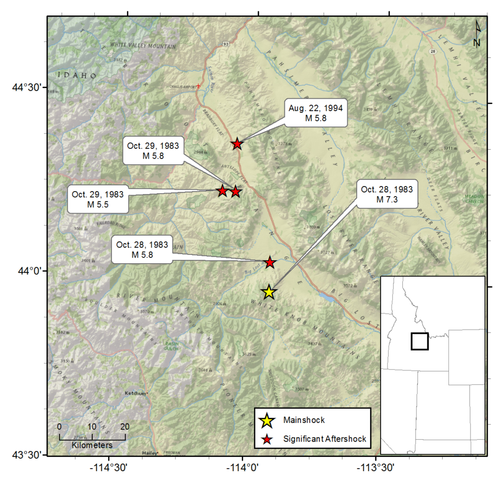
October 28, 1983 - Borah Peak, ID - M 7.3
Mainshock
The M7.3 Borah Peak mainshock occurred at 8:06 a.m. on October 28, 1983, rupturing portions of the Lost River fault and the Lone Pine fault for ~30-60 s. The earthquake created a 20+ mi long fault scarp from ~3 mi (5 km) E of Chilly, ID to ~12 mi (20 km) SW of Challis, ID, dropping the valley ~8 ft (2.5 m). This large earthquake is unique in that two groups of people witnessed the scarp forming! One hunter watched the rupture cut across the hillside, likening the sight to scissors cutting the hill. Another group of hunters were in a vehicle on the hanging wall side of the fault when the scarp formed ~60 ft in front of them, dropping them 3 ft in ~1 s; They described flying out of their seats when the vehicle dropped. Most people noted a noise described as a "horrendous roar" and "deafening rumble" and some noted seeing the ground roll like waves.
Mackay, ID experienced the most damage, being ~15 mi (24 km) SW of the epicenter. It was suggested that Challis, ID was “spared the brunt” of the shaking and subsequent damage due to the fault forking near Willow Creek Summit, with more energy diverted along the western arm of the split. Unfortunately, two children (ages 6 and 7) were killed in Challis when a building’s stone facade crumbled in the shaking. Almost 1 month after the main shock, President Reagan approved the request for a federal disaster declaration.
In Mackay, it was estimated that 80% of downtown suffered extensive fracturing. Eight buildings were subsequently condemned and razed. Four buildings in Challis were marked for demolition. In both cities the high schools were declared uninhabitable and were torn down and rebuilt. In Challis, rockfalls landed in and around homes, with one notable example of a boulder ending up in one resident’s kitchen. An elementary school in Clayton experienced minor damage from a falling boulder, but was eventually abandoned for a new location over fears of more possible rock falls from the adjacent cliffs. In all, 39 homes and 11 business in Challis and Mackay had major damage, and 200 homes and numerous businesses experienced moderate to minor damage. Final damage estimates from FEMA claims processed was $12.5 million (This excludes the cost of repairs funded by the Red Cross, Small Business Association, and private groups).
A notable observation was the earthquake’s affect on the region’s ground water. Clayton Silver Mine flooded, stopping operation for 3 months while they pumped water out of the mine. Fortunately, no one was in the mine during the earthquake or flooding. Artesian springs burst through the ground near Chilly Butte causing severe flooding of ranches in the area; eventually this water subsided. The warm springs on one rancher’s property completely disappeared during the earthquake, only to slowly come back and increase to 4x pre-earthquake levels; This increase in water threatened to flood nearby homes. Sand boils were observed near Chilly Butte and in the Lost River and Pahsimeroi Valleys, a feature typically associated with liquefaction. The earthquake was even blamed for disrupting the clockwork eruption of Old Faithful geyser in Yellowstone National Park, about 160 miles (250 km) away.
Aftershocks
More than 150 aftershocks were recorded in the first day following the mainshock. The largest occurred about 5 hours after the mainshock and is estimated as M 5.8. Two aftershocks above M5 occurred the following day (M 5.8 and M 5.5). Two aftershocks in August and September of the following year were M5.8 and M5.1, startling residents again. Aftershocks expanded north of the mainshock epicenter through 1985, roughly along I-93 and the Pahsimeroi Mountains.
For additional information about this earthquake:
Earthquake Summary Newspaper Articles Photos
Personal Accounts Additional Resources
Intermountain Seismic Belt Historical Earthquake Project
- 1945 Flathead Lake, MT M5.5
- 1952 Bigfork, MT M5.5
- 1935 Helena, MT (series) M6¼
- 1929 Lombard, MT M 5.6
- 1925 Clarkston Valley, MT M 6¾
- 1959 Hebgen Lake, MT M 7.5
- 1975 Yellowstone National Park , WY M 6.1
- 1947 Virginia City, MT M 6¼
- 1945 Central Idaho M 6.0
- 1944 Central Idaho M 6.1
- 1983 Borah Peak, ID (series) M 7.3

