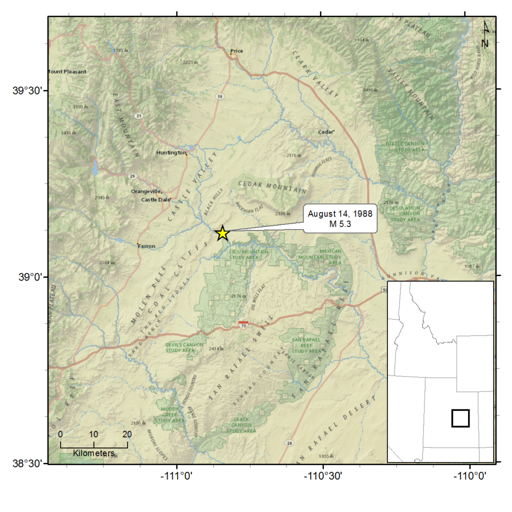
August 14, 1988 - San Rafael Swell, UT - M 5.3
This earthquake was located approximately 10 miles ESE of Castle Dale, Utah in Emery County.
There were no reports of injuries or serious damage resulting from the earthquake. Reports indicate that the earthquake was felt as far east as Golden, Colorado, as far south as Albuquerque, New Mexico, as far west as Delta, Utah, and as far north as Brigham City, Utah. The earthquake was reportedly felt particularly in valleys, while less noticed in mountain areas.
Minor damage in Emery County consisted of cracks in foundations, chimneys, and old buildings. Dishes and store goods fell from shelves and pictures were dislodged from wall hooks. Cracks and plaster damage were also observed in ceilings and walls.
Calls about the earthquake were received from several coal mines in the area, but there were no reports of injury or damage. Local dams were examined and found to be sound.
Rock falls were a notable feature of this earthquake. Fallen boulders impeded travel on some roadways. In many locations, falling rocks sent up clouds of dust that were visible for many miles.
Near the epicenter, north of Ferron, Utah a resident reported seeing dust clouds on the western ridge that partially obscured Ferron Mountain and the cliffs around the Wilberg Mine. “You couldn’t see the mountain up around Wilberg for five to 10 minutes because of the dust. Same on the desert [to the east]. Just a big string of dust from as far south to as far north as you could see.”
For additional information about this earthquake:
Earthquake Summary Newspaper Articles Photos
Personal Accounts Additional Resources
Intermountain Seismic Belt Historical Earthquake Project
- 1945 Flathead Lake, MT M5.5
- 1952 Bigfork, MT M5.5
- 1935 Helena, MT (series) M6¼
- 1928 Helena, MT M 5 ½ ±
- 1929 Lombard, MT M 5.6
- 1925 Clarkston Valley, MT M 6¾
- 1947 Virginia City, MT M 6¼
- 1959 Hebgen Lake, MT M 7.5
- 1975 Yellowstone National Park , WY M 6.1
- 1945 Central Idaho M 6.0
- 1944 Central Idaho M 6.1
- 1983 Borah Peak, ID (series) M 7.3
- 1905 Shoshone, ID M 5½ ±
- 1994 Draney Peak, ID M 5.9
- 1930 Grover, WY M 5.8
- 1975 Pocatello Valley, ID M 6.0
- 1962 Cache Valley, UT M 5.7
- 1884 Bear Lake, ID M 6.3
- 1909 Hansel Valley, UT M 6±
- 1934 Hansel Valley, UT (series) M6.6
- 1914 Ogden, UT M 5½ ±
- 1894 Ogden, UT M 5.0
- 1910 Salt Lake City, UT M 5½±
- 1949 Salt Lake City, UT M 5.0
- 1943 Magna, UT M 5.0
- 1962 Magna, UT M 5.2
- 1958 Wallsburg, UT M 5.0
- 1915 Provo, UT M 5.0
- 1900 Eureka, UT M 5½ ±
- 1876 Moroni, UT M 5.0
- 1961 Ephraim, UT M 5.0
- 1988 San Rafael Swell, UT M 5.3
- 1989 So. Wasatch Plateau, UT M 5.4
- 1901 Southern Utah M 6½±
- 1945 Glenwood, UT M 5.0
- 1910 Elsinore, UT M 5.0
- 1921 Elsinore, UT (series) M 6±
- 1967 Marysvale, UT M 5.2
- 1908 Milford, UT M 5.0
- 1959 Panguitch, UT M 5.0
- 1933 Parowan, UT M 5.0
- 1942 (Aug) Cedar City, UT M 5.0
- 1942 (Sept) Cedar City, UT M 5.0
- 1902 Pine Valley, UT (series) M 6
- 1992 St. George, UT M 5.8
- 1891 St. George, UT M 5.0
- 1887 Kanab, UT M 5.7
- 1959 Kanab, UT M 5.7

